BELMONT
COUNTY
 |
SHAEFFER,
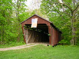
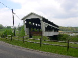
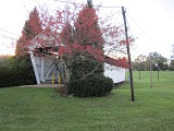
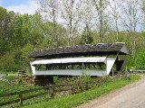
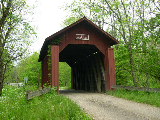
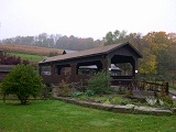
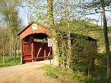
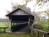
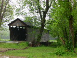
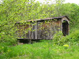
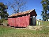
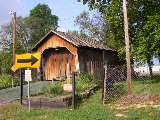
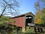
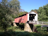
CAMPBELL BRIDGE 35-07-05, Multiple Kingpost Truss, built in 1875
is located West of St. Clairsville, at Ohio University Belmont
Campus. It was moved there in 1973.
The
GPS location is N40 04.47 W80 58.26.
|
CARROLL
COUNTY
 |
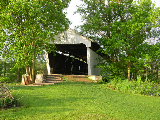
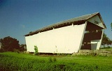
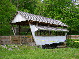
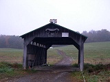
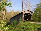
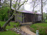
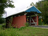
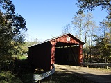
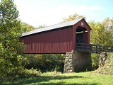
BLUE
BIRD FARM, INDIAN FORK BRIDGE 35-10-14, a 4-Panel Multiple Kingpost
Truss, built in 1996 by Jim Farley of Sebring, Ohio, one of the
newest covered bridges in Ohio. It is located South of Carrollton,
at 190 Alamo Road (Blue Bird Farm).
The
GPS location is N40 33.982 W81 04.821.
|
COSHOCTON
COUNTY
|

|
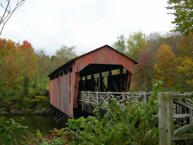
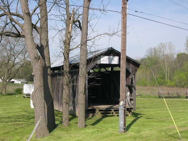
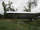
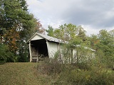
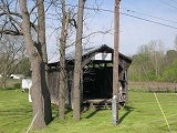
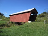
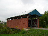
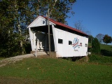
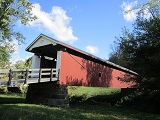
HELMICK
BRIDGE 35-16-02#2, Multiple Kingpost Truss, built in 1863 by John
Shrake, completely rebuilt in 1995 & reopened to light traffic.
It is located ESE of Blissfield on Clark Road (TR 343).
The
GPS location is N40 23.588 W81 56.567.
|
|
|
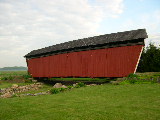
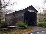
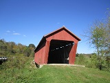
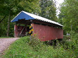
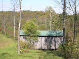
DAN
E. MILLER FARM BRIDGE 35-16-B, (Replica of a popular Multiple
Kingpost Truss), built 1981, is located East of New Bedford, off
OH 651.
The
GPS location is N40 26.205 W81 45.408.
|
FAIRFIELD
COUNTY
 |
HIZEY,
VISINTINE BRIDGE 35-23-07, Multpile Kingpost Truss variant, built
in 1891 & rebuilt in 1989, is located NE of Pickerington at
12549 Tollgate Road (Private).
The
GPS location is N39 54.876 W82 42.551.
|
 |
JON
BRIGHT BRIDGE #2 35-23-10, Inverted Bowstring & Arch Truss,
built in 1881 is located North of Lancaster, on Ohio University,
Lancaster Campus.
The
GPS location is N39 44.256 W82 35.080.
|
 |
GEORGE
HUTCHINS BRIDGE 35-23-13, Multiple Kingpost Truss, built in 1904
& rebuilt in 2000 is located in Ally Park, South of Lancaster,
off of Rte. 33 & Old Logan Road.
The
GPS location is N39 40.833 W82 34.742.
|
 |
HANAWAY,
CLEARPORT BRIDGE 35-23-15, Multiple Kingpost Truss, built in 1901
is located South of Clearport, off Clearport Road (CR 69).
The
GPS location is N39 37.106 W82 40.828.
|
 |
JOHNSTON,
TERRY MILL BRIDGE 35-23-16, Howe Truss, built in 1887 is located
ESE of Clearport, on Amanda/Clearport Road (CR 69).
The
GPS location is N39 36.81 W82 39.56.
|
 |
ZELLER-SMITH,
SYCAMORE PARK BRIDGE 35-23-19, Multiple Kingpost Truss, built
in 1905 is located SE of Pickerington, in Sycamore Creek Park.
The
GPS location is N39 52.839 W82 44.812.
|
 |
SHADE
BRIDGE 35-23-20, Burr Arch Truss, built in 1871 is located SE
of Sugar Grove, on Pierson Farm.
The
GPS location is N39 36.428 W82 31.927.
|
 |
McLEERY
BRIDGE 35-23-25, Multiple Kingpost Truss, built in 1864 is located
at the Thomas Ewing Junior High School.
The
GPS location is N39 43.513 W82 35.112.
|
 |
SHRYER,
GAME FARM BRIDGE 35-23-27, Multiple Kingpost Truss variant, built
in 1865 is located West of Baltimore, on Bill Shryer Farm along
Basil-Western Road. Permission to visit is required.
The
GPS location is N39 50.746 W82 40.678.
|
 |
ANDREWS,
CHARLES HOLLIDAY BRIDGE 35-23-30, Multiple Kingpost Truss variant,
built in 1897 is located at the Southeastern edge of Millersport,
on Corn Festival Fairgrounds, on Chautauqua Blvd (Gate 4).
The
GPS location is N39 53.775 W82 31.558.
|
 |
R.
F. BAKER, WINEGARDNER BRIDGE 35-23-33, Multiple Kingpost Truss,
built in 1871 is located in West Rushville, behind the Fairfield
Union High School, off US 22.
The
GPS location is N39 45.040 W82 28.263.
|
 |
JON
RAAB BRIDGE 35-23-37, Queenpost Truss, built in 1864 is located
ENE of Lancaster, at 5695 Ireland Road. (Private)
The
GPS location is N39 43.865 W82 29.220.
|
 |
HARTMAN
#2, LOCKVILLE PARK BRIDGE 35-23-38, Queenpost Truss, built in
1888, is located NW of Carroll, at Lockport Village Park, along
Pickerington Road (CR 20).
The
GPS location is N39 49.070 W82 44.223.
|
 |
MINK
HOLLOW BRIDGE 35-23-43, Multiple Kingpost Truss, built in 1887,
is located NE of Clearport, on Crooks Road (CR 28).
The
GPS location is N39 38.329 W82 39.000.
|
 |
ROCK
MILL BRIDGE 35-23-48, Queenpost Truss, built in 1901, is located
WNW of Lancaster, on Rock Mill Road (CR 41).
The
GPS location is N39 44.950 W82 42.801.
|
 |
ROLEY
SCHOOL HOUSE BRIDGE 35-23-49, Multiple Kingpost truss, built in
1899, is located in Lancaster at the North Broad Street Entrance
to County Fairgrounds.
The
GPS location is N39 43.477 W82 36.093.
|
 |
COVERED
BRIDGE ESTATE BRIDGE 35-23-D, Stringer, unknown date of construction,
was built to be a replica of the former STEMEN HOUSE BRIDGE OH-23-04
using its timber. It is located at Covered Bridge Estate, on Refuge
Road.
The
GPS location is N39 54.228 W82 41.457.
|
GUERNSEY
COUNTY
 |
INDIAN
CAMP BRIDGE 35-30-04, Multiple Kingpost Truss, built in 1855,
is located NNW of Cambridge, on Knox Road (TR 68).
The
GPS location is N40 06.771 W81 38.950.
|
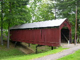 |
ARMSTRONG,
CLIO BRIDGE 35-30-12, Multiple Kingpost Truss, built in 1849,
moved in 1966, is located in the northern section of Cambridge,
in City Park.
The
GPS location is N40 02.21 W081 35.27.
|
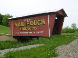 |
MAIL
POUCH BRIDGE 35-30-A, Stringer, is located west of Cumberland,
at the side of the road (private).
The
GPS location is N39 51.146 W81 40.712.
|
HARRISON
COUNTY
 |
SKULL
FORK BRIDGE 35-34-19, Multiple Kingpost Truss, built in 1876,
is located South of Freeport, off Covered Bridge Road.
The
GPS location is N40 10.981 W81 16.132.
|
HOLMES
COUNTY
|
WALNUT
CREEK, STUTZMAN'S CROSSING BRIDGE 35-38-04, Multiple Kingpost
Truss, built in 2009, is located 0.7 miles south of OH515 and
Walnut Creek Village on OH145.
The
GPS location is N40 31.89 W081 43.09.
|
 |
MILLER DRY GOOD'S BRIDGE OH-38-B, Stringer, built in 1988 is located
behind Miller Store in Charm.
The
GPS location is N40 30.457 W81 47.246.
|
 |
ELI
MAST BRIDGE OH-38-C, Stringer, built c. 1970 , is located on TR
370, North of Charm.
The
GPS location is N40 31.786 W81 47.326.
|
JEFFERSON
COUNTY
 |
DAVID
E. HINDMAN MEMORIAL BRIDGE 35-41-A, Warren Truss variant, built
in 1997, is located NE of Richmond, off SR 152.
The
GPS location is N40 27.89 W80 44.82.
|
KNOX
COUNTY
 |
BRIDGE
OF DREAMS 35-42-b, Stringer, an old Pennsylvania railroad bridge,
converted to a covered bridge, is located just East of Brinkhaven,
off US 62.
The
GPS location is N40 27.909 W82 11.622.
|
LICKING
COUNTY
|
|
BELLE
HALL BRIDGE 35-45-01, Multiple Kingpost Truss, built in 1879,
collapsed in January 1999 under heavy snow cover. It was located
East of Hartford on Dutch Cross Road.
The
GPS location was N40 14.15 W82 38.45.
|
|
|
BOY
SCOUT, RAINROCK BRIDGE 35-45-04, Multiple Kingpost Truss, building
date unknown, is located NNW of Rocky Fork in Boy Scout Camp.
(permission is needed to visit).
The
GPS location is N40 10.62 W82 18.36.
|
 |
SHOULTS,
GIRL SCOUT CAMP BRIDGE 35-45-05, Multiple Kingpost Truss, built
in 1879, is located NNW of Fallsburg, on Girl Scout Road (TR 225).
The
GPS location is N40 14.003 W82 14.985.
|
 |
GREGG
MILL, PINE BLUFF BRIDGE 35-45-06#2, Multiple Kingpost Truss, built
in 1881, is located North of Fallsburg, on Frampton Road (CR 201).
The
GPS location is N40 13.308 W82 14.304.
|
 |
LOBDELL
PARK, McLAIN BRIDGE 35-45-17, Multiple Kingpost Truss, is located
at the Southern edge of Alexandria, in Firemans Park.
The
GPS location is N40 05.166 W82 36.489.
|
 |
DAVIS
FARM BRIDGE 35-45-25, Multiple Kingpost Truss, built in 1947,
is located South of Hickman (CR 210), on private road.
The
GPS location is N40 08.112 W82 18.119.
|
 |
CANAL
GREENWAY BRIDGE, 35-45-g, Town Lattice Truss built in 1992, is
located in Canal Greenway, west of Canal Road, South of Hebron.
The
GPS location is N39 56.439 W82 31.057.
|
MAHONING
COUNTY
 |
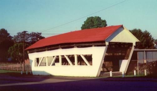
NEW
LANTERMAN'S COVERED BRIDGE 35-49-D, Stringer. It is located at
Mill Creek Park between Canfield & Youngstown, off Youngstown
Blvd (OH 625).
The
GPS location is N41 04.00 W80 40.93.
|
MONROE
COUNTY
 |
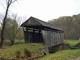
FORAKER,
WEDDLE BRIDGE 35-56-14, Multiple Kingpost Truss, built in 1886,
T-rods & I-beams added later, is located ESE of Graysville,
on Plainview Road (CR 40), in Wayne National Forest.
The
GPS location is N39 39.331 W81 07.258.
|
 |
LONG,
KNOWLTON BRIDGE 35-56-18, Multiple Kingpost Truss w/arch, built
in 1887 & completely renovated in 1995, is located North of
Rinard Mills, on Washington Road (TR 384), in Wayne National Forest.
The
GPS location is N39 36.075 W81 09.435.
|
MORGAN
COUNTY
 |
BARKHURST
MILL BRIDGE (Private) 35-58-15, Multiple Kingpost Truss w/arch,
built in 1872 & restored in 1997, is located NE of Chesterhill,
on Marion Road (TR 21).
The
GPS location is N39 30.165 W81 50.043.
|
 |
ROSSEAU,
GLASS BRIDGE 35-58-32, Multiple Kingpost Truss, unknown building
date, was the first covered bridge in Ohio to be moved for preservation
purposes in 1953. It is located at the southeastern edge of McConnelsville,
on County Fairgrounds.
The
GPS location is N39 38.383 W81 50.371.
|
 |
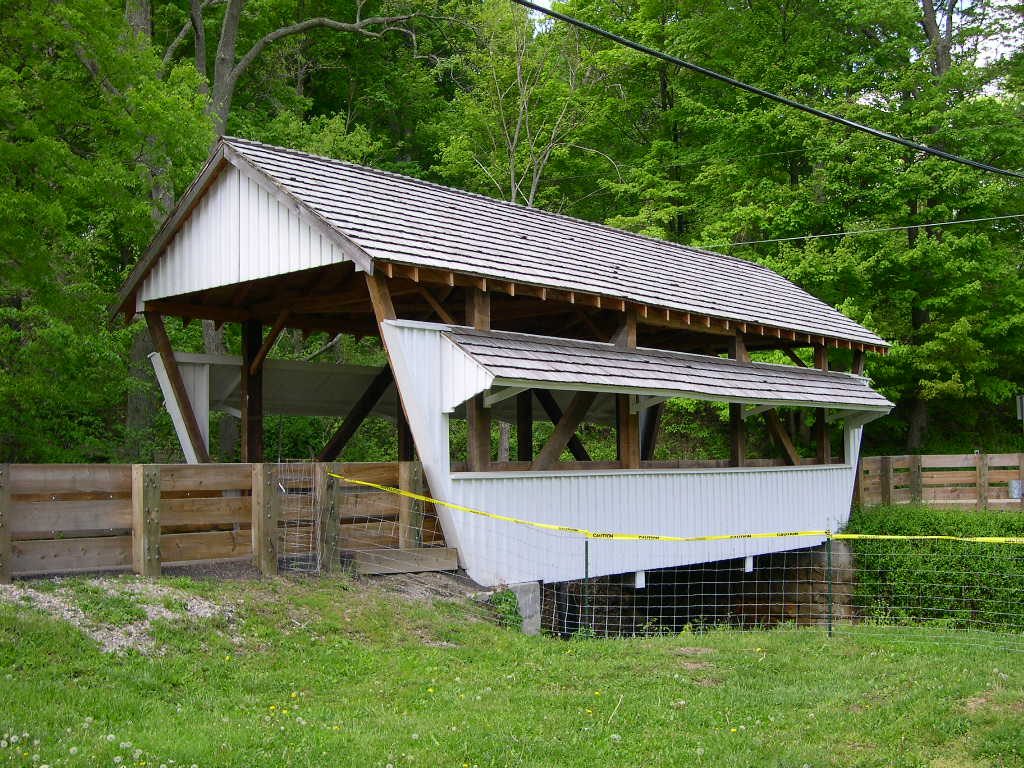
HELMICK MILL BRIDGE 35-58-35, Multiple Kingpost Truss, built in
1867 & restored in 1998, is located SE of Eagleport, on Deerfield
Road (TR 269).
The
GPS location is N39 43.186 W81 56.534.
|
 |
SAN
TROY, ADAMS BRIDGE 35-58-38, Multiple Kingpost Truss, built in
1875, is located south of Portersville, on Union Road (TR 16).
The
GPS location is N39 37.446 W82 01.937.
|
 |
MILTON
DYE, SAW MILL BRIDGE 35-58-41, formerly 35-61-27, Multiple Kingpost
Truss, built in 1915 in Noble County & moved in 1965 by the
Ohio Power Company. It is located NE of Bristol at Ohio Power
Company Campsite D, off Sawmill Road.
The
GPS location is N39 44.133 W81 41.406.
|
MUSKINGUM
COUNTY
 |
JOHNSON'S
MILL, SALT CREEK BRIDGE 35-60-31, Warren Truss, built in 1876
& restored in 1997-98, is located ENE of Zanesville, off Arch
Hill Road (CR 82).
The
GPS location is N39 59.941 W81 50.377.
|
NOBLE
COUNTY
 |
MANCHESTER,
WILEY BRIDGE 35-61-33, Multiple Kingpost Truss, built in 1915,
was by-passed in 1998. It is located South of Olive Green, on
Sharon Road (TR 3).
The
GPS location is N39 42.981 W81 37.000.
|
 |
PARRISH
BRIDGE 35-61-34, Multiple Kingpost Truss, built in 1914 is located
SSW of Sharon, off Sharon Road (TR3).
The
GPS location is N39 42.367 W81 35.091.
|
 |
PARK
HILL ROAD BRIDGE 35-61-40, Multiple Kingpost Truss, building date
unknown is located at the Southwestern edge of Caldwell, in the
County Fairgrounds, off Park Hill Road.
The
GPS location is N39 44.530 W81 31.850.
|
|
NO
PHOTO!
|
HUFFMAN
WOOD BRIDGE 0H-61-57, Multiple Kingpost Truss, was destroyed by
a flood in August 1998. It was located SE of Middleburg on a farm
access road. |
PERRY
COUNTY
 |
PARKS,
SOUTH BRIDGE 35-64-02, Multiple Kingpost Truss, built in 1883
is located North of Somerset, on Gower Road (CR 33).
The
GPS location is N39 51.148 W82 16.753.
|
 |
HOPEWELL
CHURCH BRIDGE 35-64-03, Multiple Kingpost Truss, built in 1874
is located North of Somerset, on Cooperriders Road (CR 51).
The
GPS location is N39 51.823 W82 16.986.
|
 |
JACK'S
HOLLOW, DOLLINGS BRIDGE 35-64-05, Multiple Kingpost Truss, built
in 1879, was damaged by arson in 1989 & restored. It is located
NE of Mt. Perry, on Madison Road (TR 108).
The
GPS location is N39 54.432 W82 10.112.
|
 |
BOWMAN
MILL, REDINGTON BRIDGE 35-64-06, Multiple Kingpost Truss, built
in 1859, is located West of New Lexington at the Fairground entrance,
off OH 37.
The
GPS location is N39 43.252 W82 13.474.
|
 |
MARY RUFFNER/MOORE BRIDGE 35-64-84, formerly 35-23-31, Smith Truss,
built in Fairfield County in 1875, was moved to its present location
in 1986, on private land. It is located SSE of Thornton, at 374
Somerset Road (OH 13).
The
GPS location is N39 50.925 W82 23.521.
|
WASHINGTON
COUNTY
 |
SHINN
BRIDGE 35-84-03, Multiple Kingpost Truss w/arch, built in 1886,
is located SW of Wolf Creek, on Palmer Road (TR447).
The
GPS location is N39 27.772 W81 45.667.
|
 |
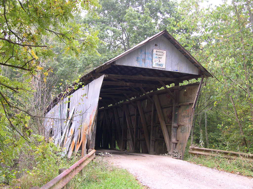
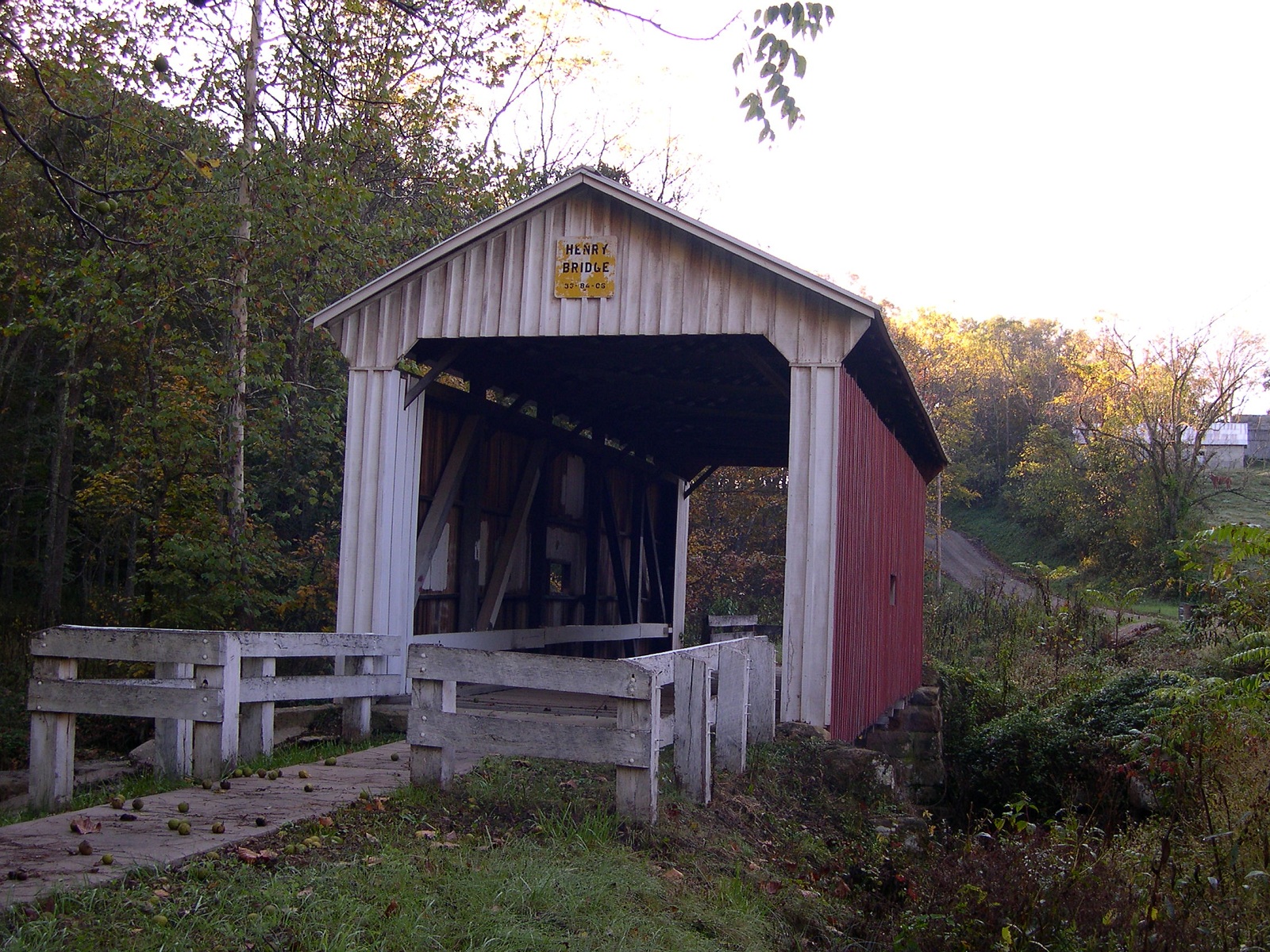
HENRY BRIDGE 35-84-06, Multiple Kingpost Truss, built in 1894,
is located SE of Bartlett, off Fairfield Road (TR 61).
The
GPS location is N39 22.998 W81 47.117.
|
 |
ROOT,
QUALEY BRIDGE 35-84-08, Long Truss, built in 1878, is located
North of Decaturville, off CR 6.
The
GPS location is N39 20.545 W81 45.266.
|
 |
HARRA BRIDGE 35-84-11, Long Truss, built in 1878, is located NW
of Watertown, off Watertown Road (TR 172).
The
GPS location is N39 29.270 W81 38.868.
|
 |
BELL
BRIDGE 35-84-12, Multiple Kingpost truss, built in 1888, is located
NNW of Barlow on Barlow Road (TR 39).
The
GPS location is N39 25.874 W81 40.573.
|
 |
MILL
BRANCH, BARLOW BRIDGE 35-84-17, Multiple Kingpost Truss, built
c. 1855, is located at Barlow, on Fairgrounds, off OH 550.
The
GPS location is N39 23.959 W81 40.058.
|
 |
SCHWENDERMAN,
BENEDICT BRIDGE 35-84-20, Multiple Kingpost Truss, built in 1894,
is located South of Macksburg, off CR8, on the east side of the
road.
The
GPS location is N39 34.754 W81 27.192.
|
 |
HILLS,
HILDRETH BRIDGE 35-84-24, Howe Truss, built in 1878, is located
East of Marietta, on CR 333.
The
GPS location is N39 25.644 W81 21.692.
|
 |
GALLAGHER'S
FORD, HUNE BRIDGE 35-84-27, Long Truss, built in 1879, is located
SW of Bloomfield, on Lawrence Road (TR 34).
The
GPS location is N39 30.629 W81 15.019.
|
 |
RINARD
BRIDGE 35-84-28#2, Smith Truss, built in 1876, destroyed by Hurricane
Ivan in 2004, rebuilt in 2006, is located SW of Bloomfiled, off
CR 406.
The
GPS location is N39 32.21 W81 13.35.
|
|